


ISS通過予測
ISS通過予測の説明
このアプリケーションは、国際宇宙ステーション(ISS)の太陽、月または惑星の通過を計算します。
計算地点(緯度、経度、標高)を入力します。そして、最新の軌道要素をダウンロードします。計算地点から指定した距離(アラート半径)内にある通過予測を計算し、結果を地図上に表示します。
Proバージョンのみの機能:複数の計算地点を指定、保存できます。後で参照するために複数の予測マップを保存できます。軌道要素を指定できます。通過予測をカレンダーに追加。マップをGoogle Earthで見ることができます。広告がありません。
Proバージョンのみの機能:天宮宇宙ステーションやハッブル宇宙望遠鏡など、あらゆる衛星の通過を計算します。(アプリ内購入が可能: 追加の衛星のロックを解除)
ユーザーインターフェース
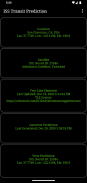
メイン画面には、5つのボタンがあります。
・計算地点 - 予測を計算する地点を追加または選択します。
・衛星 - このボタンを押して、通過衛星を変更します (Proバージョンのみの機能, アプリ内購入が必要です)。
・軌道要素(TLE) - 軌道要素をダウンロードします。
・予測の計算 - このボタンをタップすると予測の計算が始まります。
・予測の表示 - 予測結果を地図上またはテキストで表示します。
オプションメニューには、次の機能があります。
・計算地点 - 予測を計算する地点の追加、選択、編集、削除します(Proバージョンのみ)。
・予測の表示 - 保存した予測マップを見たり、シェアしたり、削除します(Proバージョンのみ)。
・設定 - ユーザー設定をします。
・DEMファイル-ダウンロードした標高データを表示または削除します。
・ヘルプ - ヘルプを表示します。
・ISS通過予測について - アプリケーションのバージョン、クレジット、リンクを表示します。
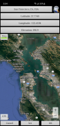
計算地点
メイン画面からアクセスできる「計算地点」ボタンをクリックして、名前付き計算ポイントを追加します。
計算されたポイントは、次のいずれかの方法で入力できます:
・手動入力 - テキストボックスに緯度、経度、標高を入力します。北緯、東経の場合はプラスの数値で、南緯、西経の場合はマイナスの数値で入力します。標高は、現在の単位系の設定に応じて、海面からの高さをメートルまたはフィートで入力することができます。座標を入力すると地図はその地点に移動します。または、右上の検索ボタンのタップで計算地点を検索します。
・地図入力 - 地図を拡大、移動して計算地点を表示します。設定ボタンをタップすると、テキストボックスに計算地点名、座標、標高が入力されます。この座標の標高は、標高データソースの設定にしたがい入力されます。地図/衛星ボタンのタップで、地図か衛星写真かを切り替えます。
・GPS入力 - GPSボタンのタップで、GPSを使用して座標と標高を入力します。
オプションメニューの計算地点から保存した場所の編集や削除をします。(Proバージョンのみ)
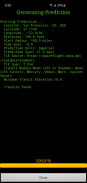
予測の計算
計算地点を入力し、軌道要素をダウンロードして、"予測の計算"をタップすると計算が始まります。プログレスバーで計算がどれくらいで終了するか分かります。プロセッサーの計算スピードにより、数分かかることがあります。キャンセルボタンをタップすると計算を中止します。
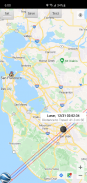
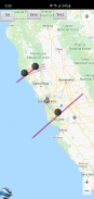
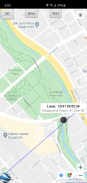
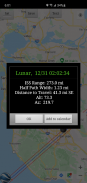
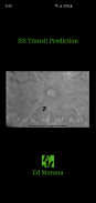
予測の表示
計算が終わると、予測マップやテキストファイルで計算結果を見ることができます。予測の表示をタップすると、以前に計算した予測マップをを表示します。地図表示画面のテキストボタンのタップで予測テキストを表示します。地図/衛星ボタンのタップで地図モードと衛星写真モードを切り替えます。
地図表示画面のGoogle Earthボタンのタップで、Google Earthでマップを表示します(Proバージョンのみ)。後で参照するために予測を保存するには、保存ボタンをタップしてください(Proバージョンのみ)。
通過情報画面でカレンダーに追加ボタンをタップするとカレンダーに追加します(Proバージョンのみ)。
保存した予測マップを表示、シェアおよび削除するには、オプションメニューの予測の表示をタップします(Proバージョンのみ)。
許可
現在地情報:ファイン(GPS)ロケーション。ユーザーの要求に応じて、現在位置情報を取得します。
ISS通過予測- APK情報
APKバージョン: 3.1.1パッケージ: com.ed_morana.iss_transit_prediction_freeISS通過予測の最新バージョン
他のバージョン


同じカテゴリのアプリ

 4.044.383.784.474.55
その他のおすすめ...


